
Put back what each acre took off
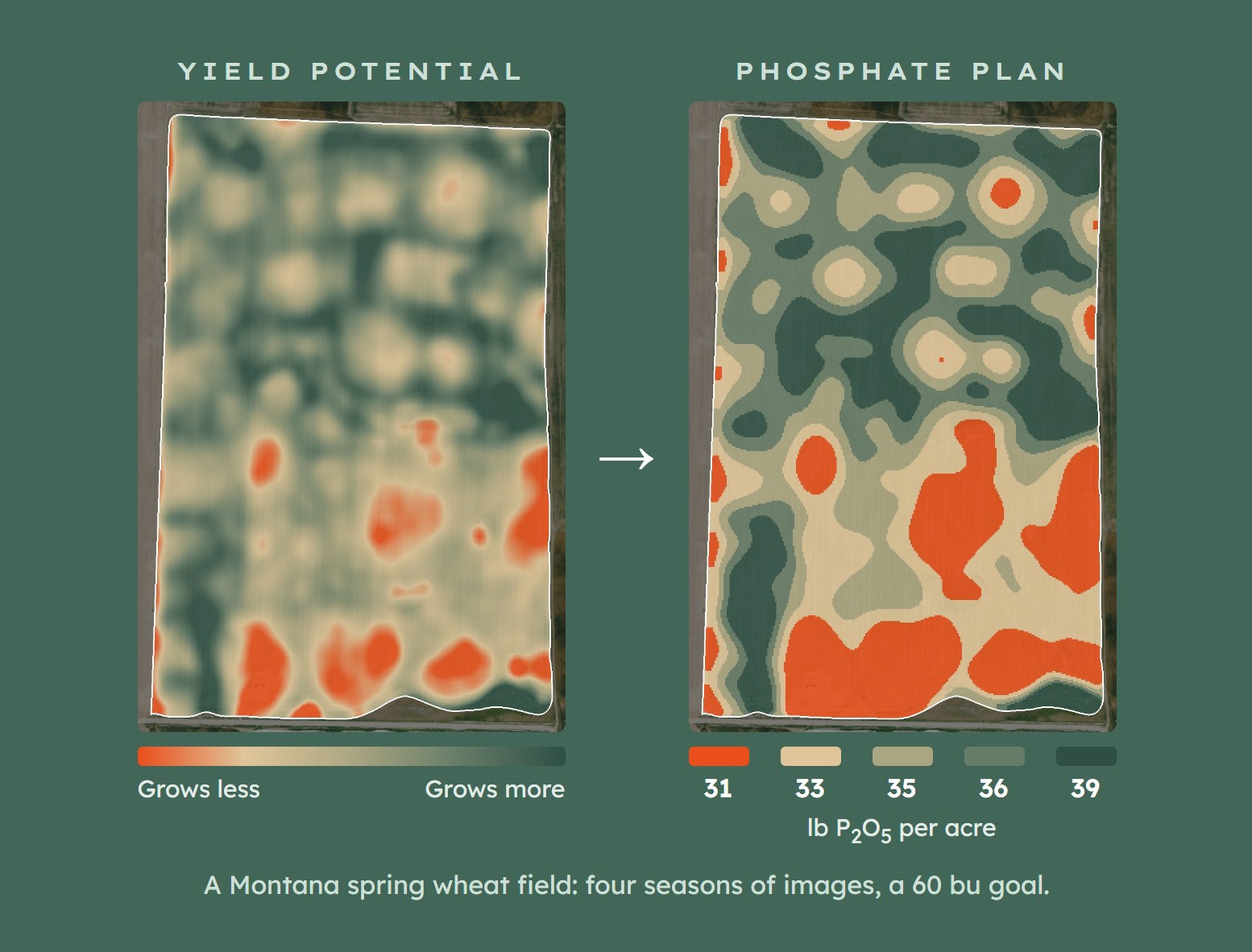
Years of satellite images show what each part of a field grows. FarmIQ turns that into a fertilizer plan for your drill that replaces what the crop removed. No soil scan needed.
How It Works
1. We Read Your Field's History
We pull the satellite image from peak growth in every past season, crop by crop. Ground that grows more year after year shows up strong. Ground that lags shows up weak.
2. We Set the Rates
Each zone's yield goal times what your wheat, canola or pulses remove per bushel. That is the phosphorus, potassium and sulfur the plan puts back.
3. It Goes to Your Drill
The plan comes as a standard prescription file for your display, ready for the first pass of the season.
The same fertilizer, moved to where it pays
On this field, a 60 bu spring wheat goal at 0.58 lb of P2O5 removed per bushel works out to 34.8 lb an acre flat. The replacement plan runs from 31 lb on the weak ground to 39 lb on the strong ground, and still averages 34.8.
You buy the same phosphate. It just lands where the crop takes it off.
Already have soil tests or a SoilOptix map? We use them to catch spots running low. Soil mapping →
What we need to start
- Field boundaries, or land locations
- Your drill and rate controller
- The fertilizer products you run
- Yield files and soil tests help, but aren't needed
Common questions
FarmIQ satellite imagery is $0.25 an acre for the season. Replacement RX prescriptions are $0.50 an acre per nutrient, or $2.50 an acre for all maps, with unlimited runs each season (full price list).
No. The plan is built from satellite yield potential and crop removal. If you have soil tests or a SoilOptix map, we use them to raise the rate where a nutrient runs low.
Send your yield files after harvest and next year's plan gets sharper. If they live in John Deere Operations Center or CNH AFS, FarmIQ can pull them in.
Yes. The satellite images cover the Prairies the same as Montana. We use your province's removal values, or your agronomist's numbers if you'd rather.
Shapefile and ISOXML for the cab, plus a PDF to review. Tell us what's in your cab and we check the format first.
Get a plan for your fields
Send us your boundaries and what you seed, and we'll show you the map before you book fertilizer.